Traffic Volume Prediction
Basic -
In today's world traffic problems are at peak. Our topic deals with the traffic volume prediction for vehicle counting. Many researches have been done in past but installing traffic monitoring devices used to be a long process and caused major traffic disruptions. As a major component of Integrated Transportation System, advanced traffic management systems focus on making efficient policies to reduce traffic congestion and to raise the road utilization ratio.It is essential to know the magnitude of traffic data required or to be collected, which will then determine its quality and type of vehicle classification to be adopted.
Primitive method -
1. Pneumatic tubes:
These tubes are placed on the top of road surfaces where vehicle counting is required. One or more rubber hoses are stretched across the road and connect one end to the data logger while the other end is sealed. When a pair of wheels hits the tube, air pressure in the squashed tube activated the data logger which records the time of event. The data logger can establish vehicle’s direction by recording which tube is crossed first when many tubes are stretched across several lanes of traffic. But this has a disadvantage that if two vehicles cross the tubes at the same time then the direction can’t be accurately determined. One has to physically download the count onto a computer from the loggers at the roadside. They work well for short duration counts on lower volume roads as they are not effective on higher volume or multi-lane highways.
2. Inductive loops: Inductive loop detector consists of an embedded turned wire, an oscillator and a cable. The square of wire embedded into or under the road allows signals to pass from the loop to the traffic counting device. The loop follows the principle that a magnetic field introduced near an electrical conductor causes an electric current to be induced. The metal vehicle acts as the magnetic field and the inductive loop as the electrical conductor. They are widely used equipment for vehicle counting and detection as they are cheap and maintenance-free. Single loops are incapable of measuring the speed and length of the vehicle whereas by inductive loop, the length of the vehicle is derived from driving time i.e., the time taken by the vehicle to drive from the first to the second loop and cover time i.e., the time during which the vehicle was over the first and the second loop. The resulting length is called the electrical length and is generally less than the actual length of the passing vehicle due to built-in threshold, the road surface, the feeder length, the distance between the bottom of the vehicle and the loop or the synthetic materials used in modern cars. It can be used for any level of traffic.
3. Piezoelectric sensor: It is mounted in a groove cut into road’s surface as data can be collected by converting mechanical energy into electrical energy. When a car drives over the piezoelectric sensor, car creates a pressure on the sensor which causes an electric potential-a voltage signal. The size of the signal is proportional to the degree of deformation. When the moves off, the voltage reverses and this change in voltage can be used to detect and count vehicles. The counting device is housed in an enclosure by the side of the road which is connected to the sensors. Data can be collected locally via an Ethernet or RS232 connection to a laptop, or may be transmitted by modem.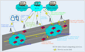
5. Magnetic sensors: These sensors may be buried in the road or enclosed in a box by the side of the road. As the vehicle passes over the detector, the sensor detects it by measuring the change in the earth’s magnetic field. The magnetic detector may have difficulty in discriminating between the vehicles when they follow each other very closely.
6. Acoustic detector: The sensor is mounted on a pole pointing down towards the traffic. It detects vehicles by the sound they create when they pass. It can collect data from more than one lane. They can communicate their counts wirelessly.
7. Passive infrared: Passive infrared devices detect vehicles by measuring the infrared energy radiating from the detection zone. When a vehicle passes the energy radiated changes and the count is increased. Slow changes in road surface temperature caused by changing weather conditions, are ignored. Lane coverage is limited to one or two lanes.
8. Doppler microwave sensors: Doppler microwave detection devices transmit a continuous signal of low-energy microwave radiation at a target area and then analyse the reflected signal. The change in the frequency of waves occurring when the microwave source and the vehicle are in motion relative to one another is registered by the detector. This allows the device to detect moving vehicles.
9. Radar detectors: Radar detectors actively emits radioactive signals and can register vehicular presence and speed depending upon signals returned upon reflection. The device directs high frequency radio waves at the roadway to determine the time delay of the return signal resulting in calculating the distance to the detected vehicle. They can operate day and night and are very little susceptible to adverse weather conditions.
Traffic flow prediction by manual counts:
Manual counts: A manual classified counts involves counting all the vehicles passing a selected location on a road for a pre determined period of time. The count is conducted by persons standing at the roadside and recording passing vehicles on a form, hence the term” manual traffic counts”. This distinguishes it from counts by machines that can record passing vehicles automatically, which are known as “automatic traffic counts”. The counts records individual vehicles by categories and the direction they are travelling in. This is the reason it is called classified counts.
Procedure:
1.Number of observers required depends upon no. of lanes and type of information required.
2.More desirable to record traffic in each direction of travel by posting separate observers for each direction.
3.For all day counts work in three shifts are arranged.
4.Data is recorded by five dash system.
Advantages:
1.Details such as vehicle classification and no. of occupants can be obtained.
2.Records turning movement data of vehicles at intersections.
3.Analyzing traffic characteristics in unusual conditions such as adverse weather conditions, traffic breakdowns, temporary closure of any lane of highway etc.
4.Comparatively cheaper method of counting.
5.Data accumulated by manual methods are easy to analyze.
Disadvantages:
1.Not practical to have manual counts for 24 hours of the day and throughout the year.
2.Counts of remote areas are possible by automatic devices.
Traffic flow prediction using pneumatic tubes:
Principles of Operation
Pneumatic road tube sensors send a burst of air pressure along a rubber tube when a vehicle's tires pass over the tube. The pressure pulse closes an air switch, producing an electrical signal that is transmitted to a counter or analysis software. The pneumatic road tube sensor is portable, using lead-acid, gel, or other rechargeable batteries as a power source.
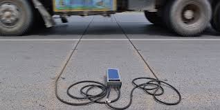
Applications and Uses
The road tube is installed perpendicular to the traffic flow direction and is commonly used for short-term traffic counting, vehicle classification by axle count and spacing, planning, and research studies. Some models gather data to calculate vehicle gaps, intersection stop delay, stop sign delay, saturation flow rate, spot speed as a function of vehicle class, and travel time when the counter is utilized in conjunction with a vehicle transmission sensor (JAMAR Technologies).
Advantages
Advantages of road tube sensors are quick installation for permanent and temporary recording of data and low power usage. Road tube sensors are usually low cost and simple to maintain. Sensor manufacturers often supply software packages to assist with data analysis.
Disadvantages
Disadvantages include inaccurate axle counting when truck and bus volumes are high, temperature sensitivity of the air switch, and cut tubes from vandalism and truck tire wear.
Traffic Flow Prediction with Rainfall Impact
Traffic flow prediction is an important component of traffic modeling, operation, and management. Accurate real-time traffic flow prediction can
(1) provide information and guidance for road users to optimize their travel decisions and to reduce costs and
(2) help authorities with advanced traffic management strategies to mitigate congestion.
With regard to the impact of rainfall, there is general consensus that it significantly affects traffic flow characteristics and leads to congestion and accidents.
Without a comprehensive understanding of the weather influence on traffic flow, traffic management authorities cannot consider relevant factors in related operational policies to improve traffic efficiency and safety. For rainfall-integrated traffic flow prediction using machine learning methods, Dunne and Ghosh combined stationary wavelet transform and BPNN to develop a predictor that could choose between a dry model and a wet model depending on whether rainfall is expected in the prediction hour. The results show that rainfall-integrated predictor could improve the prediction accuracy during rainfall events. Deep learning tools provide a promising avenue to incorporate the impacts of rainfall in traffic flow prediction.

In this, a systematic procedure to predict traffic flow considering rainfall impact using the deep learning method is presented. The main contribution of this work is to investigate whether the deep learning models can outperform typical methods with multisource data. This study also aims to compare the difference between advanced recurrent NN and basic deep learning NN for the prediction of time series traffic flow. In addition, the temporal and spatial characteristics can also be included with multiply sets of traffic detectors.
2. Inductive loops: Inductive loop detector consists of an embedded turned wire, an oscillator and a cable. The square of wire embedded into or under the road allows signals to pass from the loop to the traffic counting device. The loop follows the principle that a magnetic field introduced near an electrical conductor causes an electric current to be induced. The metal vehicle acts as the magnetic field and the inductive loop as the electrical conductor. They are widely used equipment for vehicle counting and detection as they are cheap and maintenance-free. Single loops are incapable of measuring the speed and length of the vehicle whereas by inductive loop, the length of the vehicle is derived from driving time i.e., the time taken by the vehicle to drive from the first to the second loop and cover time i.e., the time during which the vehicle was over the first and the second loop. The resulting length is called the electrical length and is generally less than the actual length of the passing vehicle due to built-in threshold, the road surface, the feeder length, the distance between the bottom of the vehicle and the loop or the synthetic materials used in modern cars. It can be used for any level of traffic.
3. Piezoelectric sensor: It is mounted in a groove cut into road’s surface as data can be collected by converting mechanical energy into electrical energy. When a car drives over the piezoelectric sensor, car creates a pressure on the sensor which causes an electric potential-a voltage signal. The size of the signal is proportional to the degree of deformation. When the moves off, the voltage reverses and this change in voltage can be used to detect and count vehicles. The counting device is housed in an enclosure by the side of the road which is connected to the sensors. Data can be collected locally via an Ethernet or RS232 connection to a laptop, or may be transmitted by modem.
5. Magnetic sensors: These sensors may be buried in the road or enclosed in a box by the side of the road. As the vehicle passes over the detector, the sensor detects it by measuring the change in the earth’s magnetic field. The magnetic detector may have difficulty in discriminating between the vehicles when they follow each other very closely.
6. Acoustic detector: The sensor is mounted on a pole pointing down towards the traffic. It detects vehicles by the sound they create when they pass. It can collect data from more than one lane. They can communicate their counts wirelessly.
7. Passive infrared: Passive infrared devices detect vehicles by measuring the infrared energy radiating from the detection zone. When a vehicle passes the energy radiated changes and the count is increased. Slow changes in road surface temperature caused by changing weather conditions, are ignored. Lane coverage is limited to one or two lanes.
8. Doppler microwave sensors: Doppler microwave detection devices transmit a continuous signal of low-energy microwave radiation at a target area and then analyse the reflected signal. The change in the frequency of waves occurring when the microwave source and the vehicle are in motion relative to one another is registered by the detector. This allows the device to detect moving vehicles.
9. Radar detectors: Radar detectors actively emits radioactive signals and can register vehicular presence and speed depending upon signals returned upon reflection. The device directs high frequency radio waves at the roadway to determine the time delay of the return signal resulting in calculating the distance to the detected vehicle. They can operate day and night and are very little susceptible to adverse weather conditions.
Traffic flow prediction by manual counts:
Manual counts: A manual classified counts involves counting all the vehicles passing a selected location on a road for a pre determined period of time. The count is conducted by persons standing at the roadside and recording passing vehicles on a form, hence the term” manual traffic counts”. This distinguishes it from counts by machines that can record passing vehicles automatically, which are known as “automatic traffic counts”. The counts records individual vehicles by categories and the direction they are travelling in. This is the reason it is called classified counts.
Procedure:
1.Number of observers required depends upon no. of lanes and type of information required.
2.More desirable to record traffic in each direction of travel by posting separate observers for each direction.
3.For all day counts work in three shifts are arranged.
4.Data is recorded by five dash system.
Advantages:
1.Details such as vehicle classification and no. of occupants can be obtained.
2.Records turning movement data of vehicles at intersections.
3.Analyzing traffic characteristics in unusual conditions such as adverse weather conditions, traffic breakdowns, temporary closure of any lane of highway etc.
4.Comparatively cheaper method of counting.
5.Data accumulated by manual methods are easy to analyze.
Disadvantages:
1.Not practical to have manual counts for 24 hours of the day and throughout the year.
2.Counts of remote areas are possible by automatic devices.
Traffic flow prediction using pneumatic tubes:
Principles of Operation
Pneumatic road tube sensors send a burst of air pressure along a rubber tube when a vehicle's tires pass over the tube. The pressure pulse closes an air switch, producing an electrical signal that is transmitted to a counter or analysis software. The pneumatic road tube sensor is portable, using lead-acid, gel, or other rechargeable batteries as a power source.
Applications and Uses
The road tube is installed perpendicular to the traffic flow direction and is commonly used for short-term traffic counting, vehicle classification by axle count and spacing, planning, and research studies. Some models gather data to calculate vehicle gaps, intersection stop delay, stop sign delay, saturation flow rate, spot speed as a function of vehicle class, and travel time when the counter is utilized in conjunction with a vehicle transmission sensor (JAMAR Technologies).
Advantages
Advantages of road tube sensors are quick installation for permanent and temporary recording of data and low power usage. Road tube sensors are usually low cost and simple to maintain. Sensor manufacturers often supply software packages to assist with data analysis.
Disadvantages
Disadvantages include inaccurate axle counting when truck and bus volumes are high, temperature sensitivity of the air switch, and cut tubes from vandalism and truck tire wear.
Traffic Flow Prediction with Rainfall Impact
Traffic flow prediction is an important component of traffic modeling, operation, and management. Accurate real-time traffic flow prediction can
(1) provide information and guidance for road users to optimize their travel decisions and to reduce costs and
(2) help authorities with advanced traffic management strategies to mitigate congestion.
With regard to the impact of rainfall, there is general consensus that it significantly affects traffic flow characteristics and leads to congestion and accidents.
Without a comprehensive understanding of the weather influence on traffic flow, traffic management authorities cannot consider relevant factors in related operational policies to improve traffic efficiency and safety. For rainfall-integrated traffic flow prediction using machine learning methods, Dunne and Ghosh combined stationary wavelet transform and BPNN to develop a predictor that could choose between a dry model and a wet model depending on whether rainfall is expected in the prediction hour. The results show that rainfall-integrated predictor could improve the prediction accuracy during rainfall events. Deep learning tools provide a promising avenue to incorporate the impacts of rainfall in traffic flow prediction.
In this, a systematic procedure to predict traffic flow considering rainfall impact using the deep learning method is presented. The main contribution of this work is to investigate whether the deep learning models can outperform typical methods with multisource data. This study also aims to compare the difference between advanced recurrent NN and basic deep learning NN for the prediction of time series traffic flow. In addition, the temporal and spatial characteristics can also be included with multiply sets of traffic detectors.
Advance method -
Artificial intelligence in Traffic volume prediction:
Artificial intelligence is used in prediction & detection of traffic accidents and conditions (by converting traffic sensors into intelligent agents using cameras), it is used in resolving control & optimization problems, Autonomous Trucks have been initiated all over the world in recent times, Autonomous trucks will save costs, lower emissions, and improve road safety as compared to traditional trucks with human drivers.

AI in transportation:
AI in transportation & infrastructure can collect traffic data to reduce congestion and improve the scheduling of public transport, Transport is affected by traffic flow, AI will allow streamlined traffic patterns, Smarter traffic light algorithms & real-time tracking can control higher and lower traffic patterns effectively, This can be applied to public transport for optimal scheduling & routing. The transportation can use Artificial Intelligence (AI) in mission-critical tasks such as self-driving vehicles carrying passengers, AI is used to predict the paths of pedestrians and cyclists, it will decrease traffic accidents and injuries, it will allow for more diverse transportation usage and an overall reduction in emissions.
Transportation problems arise when system behavior is too difficult to model according to a predictable pattern, affected by things such as traffic, human errors, or accidents, In such cases, the unpredictability can be aided by AI, AI can use observed data to make or predict decisions appropriately, NNs & GAs are perfect AI methods to deal with these types of unpredictability. Artificial intelligence can be applied to traffic management & decision-making systems to enhance and streamline traffic management and make our roads smarter, Traffic management systems can recognize the physical & environmental conditions that can lead to heavier traffic flow & congestion, They can automatically suggest alternate routes to relieve any traffic that has been formed. Machine learning could soon be used to predict and prevent traffic jams, Artificial intelligence improves public safety, Safety of citizens when traveling by public transport in urban areas is improved by tracking crime data in real time, This will allow the police to increase its efficiency by patrolling & keeping the citizens safe.
Applications of AI:
Artificial intelligence can manage the transmission & processing of received data as well as optimize connectivity to ensure the best connection, Artificial intelligence can be used in nonlinear prediction of the behavior of systems in which inputs & outputs, Traffic demand modeling, or in modeling the transportation infrastructure health as a function of traffic, construction and weathering.
AI can be used in signal control of traffic at road intersections, ramp metering on freeways, dynamic route guidance, positive train control on railroads, AI can be used in automatic incident detection, It is used in image processing for traffic data collection & identifying cracks in pavements or bridge structures and transportation equipment diagnosis.
Advantages of AI:
1.AI will reduce traffic accidents and increase safety.
2.Artificial intelligence (AI) will create significant opportunities for automakers to reduce production costs and introduce new revenue streams, including self-driving technology, predictive maintenance, and route optimization, The long driving hours and stopping for a break will no longer be a concern with fully automated fleets.
3.Artificial intelligence technologies increases the ability to process and predict data and outcomes than humans, so, travel and transport operators will schedule public and private transportation services in a significantly improved manner.
4.AI-powered real-time traffic updates through services such as Google Maps, Using location data collected from users smartphones, these apps can predict and analyze traffic conditions in your local area so as to better inform your travel plans, These apps may may soon face direct competition from autonomous vehicles themselves.
Estimation of Annual Average Daily Traffic (AADT) and Missing Hourly Volume Using Artificial Intelligence:
Annual Average Daily Traffic (AADT) is one of the most important parameters in transportation engineering. It is calculated by adding the total vehicle volume of a highway for a year divided by 365 days. It is one of the most important traffic measures used in any transportation related projects (i.e. roadway design, transportation planning, traffic safety analysis, highway investment decision making, highway maintenance, air quality compliance study and travel demand modeling). It is also an important input variable for safety analysis and is used in Safety Analyst software and the Highway Safety Manual (Harwood, 2004). Moreover, as a part of the traffic monitoring program, every state department of transportation has to report the AADT on federal aid highways to FHWA annually (TMG, 2016). Thus, the accuracy of AADT estimation is critical to any transportation problems that uses AADT as an input parameter. However, to develop an accurate method of estimating AADT is one of the biggest challenges in transportation engineering keeping in mind the lack of enough funding.
Accurate means of measuring AADT for a road segment involves installing permanent traffic count stations or Automatic Traffic Recorders (ATRs). An ATR collects traffic data 24 hours a day and 365 days a year using traditional inductive loops, microwave radar sensors, magnetic counters, and piezoelectric sensors.
Research objectives:
1. Develop AADT estimation models using machine learning techniques for different functional classes of roadways in South Carolina
2. Compare the AADT estimated by machine learning techniques and traditional factor method used by SCDOT.
3. Develop missing hourly volume imputation models for different ATR locations using machine learning techniques.
4. Compare the missing hourly volume imputed by models using machine learning techniques and the historical average method used by SCDOT. Methods for imputing missing hourly volume:
In order to execute traffic management and traffic flow pattern predictions, a reasonable amount of traffic count data is necessary, both temporally and spatially. The technologies used for traffic data collection often produce missing or erroneous data. In an attempt to mitigate these missing data, a variety of data imputation methods have been developed. These methods have been divided into three main types: interpolation-based, statistical 11 learning-based, and prediction-based.
Research method:
The two major objectives of this research were to develop models to estimate AADT for the different functional classes of roadways in South Carolina, and to develop models for imputing missing hourly volume for the permanent traffic count stations. In order to develop models for estimating AADT, two Artificial Intelligence (AI) paradigms (i.e., Artificial Neural Network and Support Vector Regression) have been used. Following the development of the models, the results were evaluated and were compared with the traditional factor based AADT estimation method currently used by SCDOT and a traditional regression analysis method for different roadway functional classes. To develop models for imputing missing hourly volume, two Artificial Intelligence paradigms have been used and the results were compared with the historical average method of missing data imputation currently used by SCDOT. In this chapter the Artificial Intelligence paradigms that have been used in this study have been introduced. Each step of the method for developing the models for estimating AADT and imputing missing hourly volume is descried in greater depth.
How AI is taking traffic monitoring systems to next level?
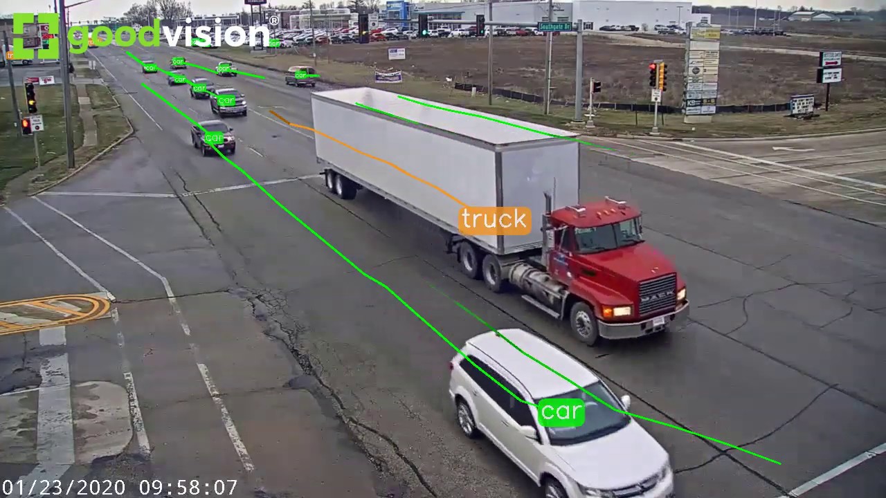
Machine learning technology is helping to improve traffic monitoring and data analytics in the transportation sector. It enhances detection accuracy and turns the collected data from cameras and sensors into valuable insights. The insights can then be used for event prediction to prevent road traffic injuries, eliminate peak-time traffic congestion, enhance operational efficiency or for future planning of traffic infrastructures.
Rise of machine learning:
Machine learning typically deals with large amounts of unstructured data like sounds and video images. Using artificial neural networks to mimic the way the human brain understands information, machine learning-based systems can learn and analyze different patterns and deliver accurate results in various conditions, unlike rule-based systems As traffic monitoring centers need to handle a large amount of data in an ever-changing target environment, this seems to be one of the best applications for this technology. Juber Chu, CEO of ACTi, indicated, “The traffic rules are generally fixed and clear. Therefore, supervised machine learning algorithms are widely applied in this sector.” Guy Baron, CTO of Qognify, expects more and more smart sensors that pack intelligent algorithms to be deployed as part of the transportation infrastructure. These can ingest and process large amounts of data in real time while helping to optimize operations by automatically identifying “cause and effect” and providing recommendations to operators for altering operational decisions to enable optimized outcomes.
Object detection and event prediction:
Machine learning helps enhance detection accuracy in identification and classification like vehicle size classification, compared to other techniques. The machine learning algorithms analyze data coming from surveillance cameras and sensors, and detect unusual patterns when they occur, like roadblocks or crowds in the middle of the street where they shouldn’t be. Deep learning is a branch of machine learning that is popular for image and video processing, and Pure Tech Systems uses it to complement other video analytic capabilities. Deep learning is very effective at classifying objects and eliminating noise within the video image. When presented with a complicated scene, or a detection scenario using a high-resolution video feed, we have found that deep learning can be extremely useful in accurately identifying targets. In the near future, we expect to see the smart systems make decisions themselves and help to deal with emergencies automatically. The system can learn traffic accident patterns and how to deal with the incident. When there is a car accident, the system will determine the number of ambulances needed, and connects to the nearest ambulance and police car via GPS to support.
More efficient monitoring: Machine learning performs pattern matching and cognitive tasks on large amounts of data that traditionally need to be scanned and processed manually. By using machine learning algorithms that perform object recognition in video footage, we can provide our users a simple and fast search mechanism to analyze scores of video content. It allows them to dramatically reduce the time, effort and ‘cognitive load’ of performing this task. It will be the norm that systems will automatically identify road hazards, security issues and predict traffic congestions while proactively prescribing corrective action in the near future. “Machine learning and AI will play a central role. Fueled by data pouring in from different sensors and data sources, intelligent algorithms will be automating more and more of operational procedures being carried out today by humans, allowing for risk to be mitigated and enhancing operational efficiency.
Improve accuracy and identification: One of prominent benefits of machine learning is the improvement in the accuracy of analytics algorithms and reliability of video surveillance cameras.
Machine vision technologies have been used in traffic monitoring applications like automatic incident detection systems for over ten years. After adding machine learning models to the system, there is a significant increase of accuracy in the recognition of people, cars, roads and other important aspects of transportation. To begin with, the ability to recognize complex car plate numbers, such as those in India, will be greatly enhanced.
Dahua started to research on intelligent algorithms in 2009, and is now very close to applying deep learning technology on its cameras for vehicle and human identification and statistical analysis. Furthermore, the machine learning algorithms can identify car features like type, make, model and color in more systematic way.
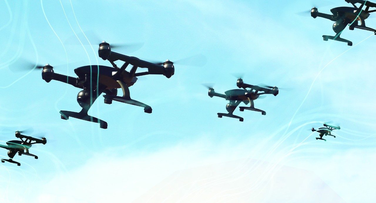
Use of drones in traffic volume prediction:
Recently, multirotor Unmanned Aerial Vehicles (UAVs) or drones have become increasingly popular for a vast variety of civil applications. Efficient traffic data collection and extraction of various flow parameters are some of the futuristic applications of this technology. However, such applications still need to be streamlined and thoroughly explored for varying traffic and infrastructural conditions. In this paper, the focus is on the authentication of the application of small multirotor UAVs for traffic data collection and subsequent analysis of traffic streams at urban roundabouts. This paper presents an analytical methodology to evaluate the performance of roundabouts by extracting various parameters and performance indicators. The performance evaluation methodology is based on: (i) determining traffic volume via OD matrices for each leg, and (ii) analyzing drivers’ behavior via gap-acceptance analysis. The overall analytical process is principally based on the authors’ previously proposed automated UAV video-processing framework for the extraction of vehicle trajectories. The extracted trajectories are further employed to extract useful traffic information. The experimental data to analyse roundabout traffic flow conditions was obtained in the city of Sint-Truiden (Belgium). The results reflect the value of flexibility and bird-eye view provided by UAV videos; thereby depicting the overall applicability of the UAV-based traffic analysis system. With the significant increase in the usage of UAVs expected in the coming years, such studies could become a useful resource for practitioners as well as future researchers. The future research will mainly focus on further extensions of the UAV-based traffic applications.
The Floating Car Data (FCD)
Data such as car location, speed and direction of travel are sent anonymously to a central processing centre. After being collected and extracted, useful information (e.g. status of traffic, alternative routes) can be redistributed to the drivers on the road. They will help improve safety, efficiency and reliability of the transportation system. They are becoming crucial in the development of new Intelligent Transportation Systems (ITS). There are two main types of FCD, namely GPS and cellular-based systems: GPS-based FCD: Even though GPS is becoming more and more used and affordable, so far only a limited number of cars are equipped with this system, typically fleet management services (e.g. taxi drivers).
Generally, traffic data obtained from private vehicles or trucks are more suitable for motorways and rural areas. In case of urban traffic, taxi fleets are particularly useful due to their high number and their on-board communication systems already in place. Currently, GPS probe data are widely used as a source of real-time information by many service providers but it suffers from a limited number of vehicles equipped and high equipment costs compared to floating cellular data.
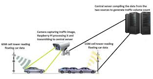
FCD based on cellular phones:
Since nowadays most of the driving vehicles are equipped with at least one or several mobile phones, it may be worth using mobile phones as anonymous traffic probes. The mobile phone positioning is regularly transmitted to the network usually by means of triangulation or by other techniques (e.g. handover) and then travel times and further data can be estimated over a series of road segments before being converted into useful information by traffic centres. Mobile phones need to be turned on, but not necessarily in use. This approach is particularly well adapted to deliver relatively accurate information in urban areas (where traffic data are most needed) due to the lower distance between antennas.
Artificial intelligence is used in prediction & detection of traffic accidents and conditions (by converting traffic sensors into intelligent agents using cameras), it is used in resolving control & optimization problems, Autonomous Trucks have been initiated all over the world in recent times, Autonomous trucks will save costs, lower emissions, and improve road safety as compared to traditional trucks with human drivers.
AI in transportation:
AI in transportation & infrastructure can collect traffic data to reduce congestion and improve the scheduling of public transport, Transport is affected by traffic flow, AI will allow streamlined traffic patterns, Smarter traffic light algorithms & real-time tracking can control higher and lower traffic patterns effectively, This can be applied to public transport for optimal scheduling & routing. The transportation can use Artificial Intelligence (AI) in mission-critical tasks such as self-driving vehicles carrying passengers, AI is used to predict the paths of pedestrians and cyclists, it will decrease traffic accidents and injuries, it will allow for more diverse transportation usage and an overall reduction in emissions.
Transportation problems arise when system behavior is too difficult to model according to a predictable pattern, affected by things such as traffic, human errors, or accidents, In such cases, the unpredictability can be aided by AI, AI can use observed data to make or predict decisions appropriately, NNs & GAs are perfect AI methods to deal with these types of unpredictability. Artificial intelligence can be applied to traffic management & decision-making systems to enhance and streamline traffic management and make our roads smarter, Traffic management systems can recognize the physical & environmental conditions that can lead to heavier traffic flow & congestion, They can automatically suggest alternate routes to relieve any traffic that has been formed. Machine learning could soon be used to predict and prevent traffic jams, Artificial intelligence improves public safety, Safety of citizens when traveling by public transport in urban areas is improved by tracking crime data in real time, This will allow the police to increase its efficiency by patrolling & keeping the citizens safe.
Applications of AI:
Artificial intelligence can manage the transmission & processing of received data as well as optimize connectivity to ensure the best connection, Artificial intelligence can be used in nonlinear prediction of the behavior of systems in which inputs & outputs, Traffic demand modeling, or in modeling the transportation infrastructure health as a function of traffic, construction and weathering.
AI can be used in signal control of traffic at road intersections, ramp metering on freeways, dynamic route guidance, positive train control on railroads, AI can be used in automatic incident detection, It is used in image processing for traffic data collection & identifying cracks in pavements or bridge structures and transportation equipment diagnosis.
Advantages of AI:
1.AI will reduce traffic accidents and increase safety.
2.Artificial intelligence (AI) will create significant opportunities for automakers to reduce production costs and introduce new revenue streams, including self-driving technology, predictive maintenance, and route optimization, The long driving hours and stopping for a break will no longer be a concern with fully automated fleets.
3.Artificial intelligence technologies increases the ability to process and predict data and outcomes than humans, so, travel and transport operators will schedule public and private transportation services in a significantly improved manner.
4.AI-powered real-time traffic updates through services such as Google Maps, Using location data collected from users smartphones, these apps can predict and analyze traffic conditions in your local area so as to better inform your travel plans, These apps may may soon face direct competition from autonomous vehicles themselves.
Estimation of Annual Average Daily Traffic (AADT) and Missing Hourly Volume Using Artificial Intelligence:
Annual Average Daily Traffic (AADT) is one of the most important parameters in transportation engineering. It is calculated by adding the total vehicle volume of a highway for a year divided by 365 days. It is one of the most important traffic measures used in any transportation related projects (i.e. roadway design, transportation planning, traffic safety analysis, highway investment decision making, highway maintenance, air quality compliance study and travel demand modeling). It is also an important input variable for safety analysis and is used in Safety Analyst software and the Highway Safety Manual (Harwood, 2004). Moreover, as a part of the traffic monitoring program, every state department of transportation has to report the AADT on federal aid highways to FHWA annually (TMG, 2016). Thus, the accuracy of AADT estimation is critical to any transportation problems that uses AADT as an input parameter. However, to develop an accurate method of estimating AADT is one of the biggest challenges in transportation engineering keeping in mind the lack of enough funding.
Accurate means of measuring AADT for a road segment involves installing permanent traffic count stations or Automatic Traffic Recorders (ATRs). An ATR collects traffic data 24 hours a day and 365 days a year using traditional inductive loops, microwave radar sensors, magnetic counters, and piezoelectric sensors.
Research objectives:
1. Develop AADT estimation models using machine learning techniques for different functional classes of roadways in South Carolina
2. Compare the AADT estimated by machine learning techniques and traditional factor method used by SCDOT.
3. Develop missing hourly volume imputation models for different ATR locations using machine learning techniques.
4. Compare the missing hourly volume imputed by models using machine learning techniques and the historical average method used by SCDOT. Methods for imputing missing hourly volume:
In order to execute traffic management and traffic flow pattern predictions, a reasonable amount of traffic count data is necessary, both temporally and spatially. The technologies used for traffic data collection often produce missing or erroneous data. In an attempt to mitigate these missing data, a variety of data imputation methods have been developed. These methods have been divided into three main types: interpolation-based, statistical 11 learning-based, and prediction-based.
Research method:
The two major objectives of this research were to develop models to estimate AADT for the different functional classes of roadways in South Carolina, and to develop models for imputing missing hourly volume for the permanent traffic count stations. In order to develop models for estimating AADT, two Artificial Intelligence (AI) paradigms (i.e., Artificial Neural Network and Support Vector Regression) have been used. Following the development of the models, the results were evaluated and were compared with the traditional factor based AADT estimation method currently used by SCDOT and a traditional regression analysis method for different roadway functional classes. To develop models for imputing missing hourly volume, two Artificial Intelligence paradigms have been used and the results were compared with the historical average method of missing data imputation currently used by SCDOT. In this chapter the Artificial Intelligence paradigms that have been used in this study have been introduced. Each step of the method for developing the models for estimating AADT and imputing missing hourly volume is descried in greater depth.
How AI is taking traffic monitoring systems to next level?
Machine learning technology is helping to improve traffic monitoring and data analytics in the transportation sector. It enhances detection accuracy and turns the collected data from cameras and sensors into valuable insights. The insights can then be used for event prediction to prevent road traffic injuries, eliminate peak-time traffic congestion, enhance operational efficiency or for future planning of traffic infrastructures.
Rise of machine learning:
Machine learning typically deals with large amounts of unstructured data like sounds and video images. Using artificial neural networks to mimic the way the human brain understands information, machine learning-based systems can learn and analyze different patterns and deliver accurate results in various conditions, unlike rule-based systems As traffic monitoring centers need to handle a large amount of data in an ever-changing target environment, this seems to be one of the best applications for this technology. Juber Chu, CEO of ACTi, indicated, “The traffic rules are generally fixed and clear. Therefore, supervised machine learning algorithms are widely applied in this sector.” Guy Baron, CTO of Qognify, expects more and more smart sensors that pack intelligent algorithms to be deployed as part of the transportation infrastructure. These can ingest and process large amounts of data in real time while helping to optimize operations by automatically identifying “cause and effect” and providing recommendations to operators for altering operational decisions to enable optimized outcomes.
Object detection and event prediction:
Machine learning helps enhance detection accuracy in identification and classification like vehicle size classification, compared to other techniques. The machine learning algorithms analyze data coming from surveillance cameras and sensors, and detect unusual patterns when they occur, like roadblocks or crowds in the middle of the street where they shouldn’t be. Deep learning is a branch of machine learning that is popular for image and video processing, and Pure Tech Systems uses it to complement other video analytic capabilities. Deep learning is very effective at classifying objects and eliminating noise within the video image. When presented with a complicated scene, or a detection scenario using a high-resolution video feed, we have found that deep learning can be extremely useful in accurately identifying targets. In the near future, we expect to see the smart systems make decisions themselves and help to deal with emergencies automatically. The system can learn traffic accident patterns and how to deal with the incident. When there is a car accident, the system will determine the number of ambulances needed, and connects to the nearest ambulance and police car via GPS to support.
More efficient monitoring: Machine learning performs pattern matching and cognitive tasks on large amounts of data that traditionally need to be scanned and processed manually. By using machine learning algorithms that perform object recognition in video footage, we can provide our users a simple and fast search mechanism to analyze scores of video content. It allows them to dramatically reduce the time, effort and ‘cognitive load’ of performing this task. It will be the norm that systems will automatically identify road hazards, security issues and predict traffic congestions while proactively prescribing corrective action in the near future. “Machine learning and AI will play a central role. Fueled by data pouring in from different sensors and data sources, intelligent algorithms will be automating more and more of operational procedures being carried out today by humans, allowing for risk to be mitigated and enhancing operational efficiency.
Improve accuracy and identification: One of prominent benefits of machine learning is the improvement in the accuracy of analytics algorithms and reliability of video surveillance cameras.
Machine vision technologies have been used in traffic monitoring applications like automatic incident detection systems for over ten years. After adding machine learning models to the system, there is a significant increase of accuracy in the recognition of people, cars, roads and other important aspects of transportation. To begin with, the ability to recognize complex car plate numbers, such as those in India, will be greatly enhanced.
Dahua started to research on intelligent algorithms in 2009, and is now very close to applying deep learning technology on its cameras for vehicle and human identification and statistical analysis. Furthermore, the machine learning algorithms can identify car features like type, make, model and color in more systematic way.
Use of drones in traffic volume prediction:
Recently, multirotor Unmanned Aerial Vehicles (UAVs) or drones have become increasingly popular for a vast variety of civil applications. Efficient traffic data collection and extraction of various flow parameters are some of the futuristic applications of this technology. However, such applications still need to be streamlined and thoroughly explored for varying traffic and infrastructural conditions. In this paper, the focus is on the authentication of the application of small multirotor UAVs for traffic data collection and subsequent analysis of traffic streams at urban roundabouts. This paper presents an analytical methodology to evaluate the performance of roundabouts by extracting various parameters and performance indicators. The performance evaluation methodology is based on: (i) determining traffic volume via OD matrices for each leg, and (ii) analyzing drivers’ behavior via gap-acceptance analysis. The overall analytical process is principally based on the authors’ previously proposed automated UAV video-processing framework for the extraction of vehicle trajectories. The extracted trajectories are further employed to extract useful traffic information. The experimental data to analyse roundabout traffic flow conditions was obtained in the city of Sint-Truiden (Belgium). The results reflect the value of flexibility and bird-eye view provided by UAV videos; thereby depicting the overall applicability of the UAV-based traffic analysis system. With the significant increase in the usage of UAVs expected in the coming years, such studies could become a useful resource for practitioners as well as future researchers. The future research will mainly focus on further extensions of the UAV-based traffic applications.
The Floating Car Data (FCD)
Data such as car location, speed and direction of travel are sent anonymously to a central processing centre. After being collected and extracted, useful information (e.g. status of traffic, alternative routes) can be redistributed to the drivers on the road. They will help improve safety, efficiency and reliability of the transportation system. They are becoming crucial in the development of new Intelligent Transportation Systems (ITS). There are two main types of FCD, namely GPS and cellular-based systems: GPS-based FCD: Even though GPS is becoming more and more used and affordable, so far only a limited number of cars are equipped with this system, typically fleet management services (e.g. taxi drivers).
Generally, traffic data obtained from private vehicles or trucks are more suitable for motorways and rural areas. In case of urban traffic, taxi fleets are particularly useful due to their high number and their on-board communication systems already in place. Currently, GPS probe data are widely used as a source of real-time information by many service providers but it suffers from a limited number of vehicles equipped and high equipment costs compared to floating cellular data.
FCD based on cellular phones:
Since nowadays most of the driving vehicles are equipped with at least one or several mobile phones, it may be worth using mobile phones as anonymous traffic probes. The mobile phone positioning is regularly transmitted to the network usually by means of triangulation or by other techniques (e.g. handover) and then travel times and further data can be estimated over a series of road segments before being converted into useful information by traffic centres. Mobile phones need to be turned on, but not necessarily in use. This approach is particularly well adapted to deliver relatively accurate information in urban areas (where traffic data are most needed) due to the lower distance between antennas.
Raspberry Pi -
MATLAB -